


Air Navigation Pro


Beschrijving van Air Navigation Pro
Ontdek onze app voor vluchtplanning en realtime navigatie 28 dagen gratis!
- Alles wat je nodig hebt om de wereld rond te vliegen
- Plan uw vlucht in een paar minuten
- Vlieg ontspannen met actuele informatie
Air Navigation Pro is een hoogwaardige vluchtassistent-app voor piloten over de hele wereld. Profiteer van de volgende belangrijkste kenmerken:
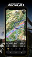
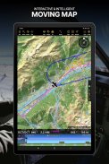
BEWEGENDE KAART
Plan en navigeer met onze interactieve bewegende kaart. Kies tussen luchtvaartkaarten, satelliet of onze vectorkaart als achtergrond. Bovendien toont de bewegende kaart waypoints, NOTAM, obstakels en luchtruimen uit onze uitgebreide, altijd up-to-date wereldwijde luchtvaartdatabase. Tik op een tussenpunt rechtstreeks op de kaart om eenvoudig een route te creëren. Personaliseer de waarden die op de navigatiebalk worden weergegeven, zodat u precies de informatie krijgt die u nodig heeft: hoogte, verticale snelheid, peiling, afstand tot het volgende tussenpunt, ETA-berekeningen, enz. Kies de vertrek- en aankomstprocedures op de luchthaven voor uw route zodat deze ook bovenaan worden weergegeven van de bewegende kaart.
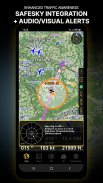
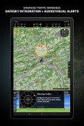
VERBETERD VERKEERSBEWUSTZIJN
Ontvang visuele en audiowaarschuwingen in alle talen voor conflicterend verkeer in de buurt. Kies het gewenste verkeerspictogram tussen algemene, vliegtuig- of TCAS-symbolen. Uw veiligheid is belangrijk voor ons en daarom werken we samen met SafeSky om ervoor te zorgen dat onze gebruikers tijdens hun vlucht over live verkeersgegevens beschikken. Profiteer van de native integratie met SafeSky, inbegrepen in onze nieuwe Smart Lite-, Smart Classic- en Smart Advanced-abonnementen: een twee-in-één pakket!
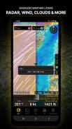
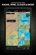
GEAVANCEERDE WEERLAGEN
Naast de basisweerrapporten van wind en TAF/METAR voor uw vlucht, kunnen abonnees van het Smart Advanced-abonnement doorzichtige weerlagen bovenop de bewegende kaart activeren. Beschikbare lagen omvatten regenradar, wind, druk, wolken en regen, zichtbaarheid, windstoten en bovendien voor Duitsland, Zwitserland, Oostenrijk en de Balkan, meldt GAFOR. Tik op een willekeurig punt op de kaart om de weersinformatie voor dat gebied te bekijken. Bekijk de weersvoorspelling voor maximaal drie dagen vooruit.
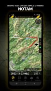
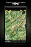
NOTAM
Nadat u uw route hebt gemaakt, stelt u de vertrektijd in de toekomst in, zodat de bewegende kaart de NOTAM voor dat specifieke tijdstip weergeeft. NOTAM op de kaart verandert dynamisch van kleur op basis van hun status.
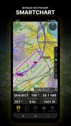
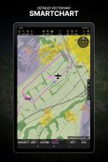
SMARTCHART
Onze geavanceerde SmartChart is een zeer gedetailleerde en intelligente vectorgebaseerde kaart die zich aanpast aan uw behoeften en u op elk zoomniveau adequate informatie biedt. De SmartChart optimaliseert de weergave van schaduwen om gemakkelijk onderscheid te maken tussen valleien en bergen, en de tekst blijft perfect uitgelijnd, waardoor een optimale leesbaarheid wordt gegarandeerd. Inclusief de laatste belangrijke verbeteringen met bossen en gedetailleerde luchthaveninformatie.
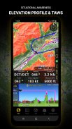
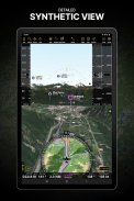
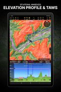
HOOGTEPROFIEL & SYNTHETISCHE AANZICHT
Schakel de profielweergave onder de navigatiebalk in voor een beter situatiebewustzijn van de hoogte voor u of langs uw route. Kies de corridorbreedte tussen 0 en 5 NM en overlay-opties: luchtruimen, NOTAM, obstakels, windcomponenten, bevolkte plaatsen, enz. Schakel over naar de synthetische weergave voor aanvullende terreininformatie, plus een kunstmatige horizon met hoogte- en verticale snelheidsindicatoren. Deze functie kan ook worden gebruikt om rond te pannen terwijl u zich voorbereidt op uw vlucht. Activeer TAWS op de bewegende kaart en op de synthetische weergave.
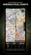
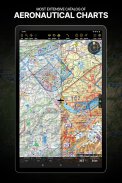
LUCHTVAARTKAART & NADERINGKAARTEN
Wij bieden de meest uitgebreide wereldwijde catalogus van luchtvaartkaarten, inclusief de ICAO-kaarten. Laat de gegeorefereerde naderingskaarten weergeven bovenop de bewegende kaart of de synthetische weergave.
BRIEFING
Bereid uw vlucht voor met onze briefingsectie door documenten te maken met NOTAM en weerkaarten en stations die relevant zijn voor uw geplande route. Optimaliseer de tijd door een vliegtuigprofiel te maken dat in de Briefing-sectie wordt gebruikt om het ATC-vluchtplan vooraf voor u in te vullen en de W&B te berekenen.
EN ZOVEEL MEER!
Met een abonnement kun je de app op drie apparaten gebruiken. We raden u aan een luchtvaartnavigatieaccount aan te maken voor verbeterd apparaatbeheer. Raadpleeg onze gebruikershandleiding op onze website: www.airnavigation.aero voor meer informatie.
Air Navigation Pro - versie 8.4.5.505070725
(08-05-2025)

Air Navigation Pro - APK-informatie
APK-versie: 8.4.5.505070725Pakket: com.xample.airnavigationNieuwste versie van Air Navigation Pro
Andere versies


Apps in dezelfde categorie

Mogelijk vind je dit ook leuk...


